
The History of Cartography, Volume 3: Cartography in the European Renaissance
History of Cartography project
Overview
- This is an enormous series. This single volume is over 2,000 pages, so this is going to be a slow read. I’m interested in this period of time because this is when maps transitioned from a kind of pictographic story to instruments of navigation. The snippets that follow reflect that focus.
Notes
- The thematic essays raise important issues in the history of cartography that both set an agenda for future research on Renaissance maps and take stock of the growing role of cartography as a way to organize social, political, and cultural space. These essays are meant to be thought provoking, rather than exhaustive, and reflect some of the multilayered approaches that the study of maps has adopted in the past two decades. They show how the authority of maps became an essential factor in influencing the ways in which Renaissance Europeans saw and imagined the geographic layout, order, and substance of the world – with “world” meaning not only an external object to be represented, but also a stage on which internal human aspirations could be played out. (p. xxxix)
- The investigation of how maps were conceived, made, and used in this period provides a case study highlighting some of these historiographical issues in a new way. Indeed it is surprising that Burckhardt completely ignored these cartographic aspects even when stressing the importance of the discovery of the world and its relationship to the discovery of the self, both topics on which the history of cartography has much to say. (p. 6)
 (p. 7)
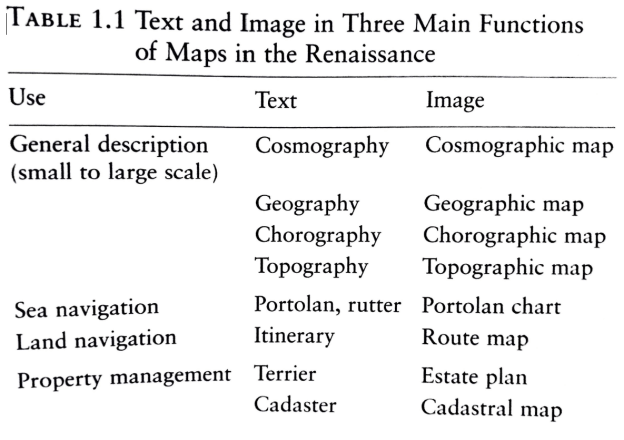
- In Volume 1 of this History, the point was made that the word mappa or mappamundi in the Middle Ages could be used to describe either a text or a map. This practice continued into the sixteenth and seventeenth centuries, as with Sebastian Munster’s Mappa Evropae (Frankfurt, 1537), John Smith’s A Map of Virginia (Oxford, 1612), or Thomas Jenner’s A Map of the Whole World (London, 1668). Indeed the metaphorical use of the word “map” to describe not only geographical descriptions but also other activities has exploded even in our own day, as we hear almost daily of the “road map” to peace in the Middle East. (p. 7)
- Likewise, the classical and medieval written land itineraries continued to be a robust tool for wayfinding, and these were by no means replaced by their graphic equivalents. Although we have a famous example of an assemblage of graphic and written itineraries in the Tabula Peutingeriana, an image whose pedigree goes back to the fourth century, written directions of how to get from one place to another predominated over maps in the medieval period. One may even question the extent to which graphic itineraries were actually used on the road. (p. 8)
- Finally, textual sailing directions, known as periploi in classical times and portolans (portolani) in the Middle Ages, continued to be favored by many sailors over their graphic equivalents into the sixteenth and seventeenth centuries, particularly in northern European waters, where they became known as rutters. The confusion still persists today, as the term “portolan” is often used when “portolan chart” is intended, leading some to propose that the term be abolished altogether. As Fernandez-Armesto argues in this volume, maps and charts were not used for navigation in the Renaissance as much as -written sailing directions. (p. 8)
- It was not derived from Ptolemy’s Geography, for Ptolemy stressed that local maps (chorographies) should not be based on measurement, but should instead be made by artists. (p. 10)
- Between 1400 and 1472, in the manuscript era, it has been estimated that there were a few thousand maps in circulation; between 1472 and 1500, about 56,000; and between 1500 and 1600, millions. The significant increase in the sheer number of maps available for viewing calls for an explanation. Certainly maps began to serve a huge variety of political and economic functions in society. (p. 11)
- The change in the abstract conception of space-from the center-enhancing mappaemundi to the Ptolemaic isotropic structure of mapmaking-has often been called the quintessential modernity of Renaissance cartography. The evidence for this lies in the relative scarcity of terrestrial maps bearing longitude and latitude before the fifteenth century. No terrestrial maps using longitude and latitude survive from thirteenth- and fourteenth-century Europe, despite Roger Bacon’s description of one on a sheepskin with cities shown by small red circles in the “Opus maius” (ca. 1265). In comparison, by the mid-seventeenth century, the observation of latitude and longitude as control points for topographical surveys had been introduced in France. What happened in the intervening four centuries is routinely ascribed to the rediscovery of Ptolemy’s manual of mapmaking in the first decade of the fifteenth century. (p. 12)
- The notion of a bounded uniform space also implies that the objects placed in it are co-synchronous, a concept that, as we shall see, led to the idea that historical and “modern” maps could and should be separate documents. Since the surface is represented as a uniform space, scale and proportion are also possible. (p. 13)
- Measurements of sufficient precision to take full advantage of the Ptolemaic paradigm were not available until astronomical measurements of latitude and longitude had become routine. (p. 13)
- Geographic coordinates were thus mainly of scholarly and not practical concern until reliable astronomical measurements of both longitude and latitude became available in the late eighteenth century, after a satisfactory chronometer had been developed. Coordinates and projection grids certainly were powerful rhetorical devices in the fifteenth and sixteenth centuries, but the data behind them was often questionable. (p. 13)
- The adoption of systematic map projections introduced a variety of centering and framing issues. The center of a projection did not usually imply either the author’s viewpoint or the most important feature to be portrayed. Unlike mappaemundi, in which Jerusalem, Delos, Rome, or some other holy place might be at the center of the map, a map such as Rosselli’s ovoid “World map” was centered on no particular place (the center is off the coast of modern Somaliland). What could be manipulated was the field of view of the projection. Since graduation in longitude and latitude forced the hand of the cartographer to some extent, the area to be covered by a projection had to be carefully calculated. (p. 14)
- The tense of medieval mappaemundi usually covered a broad span of historical time. No strong distinction between a location and an event was drawn. Places that had once been important in history but no longer existed were shown side by side with currently important places. The map told a story, often a very long one. In the fifteenth and sixteenth centuries, as the atlas became a major genre, this storytelling role was still enormously important in maps. (p. 16)
- The use of intersections of longitude and latitude that Ptolemy proposed as control points for mapmaking is not unlike the process by which a researcher gathers observations about the world and compares them against the framework of the laws of nature. It is not surprising that the map has been used as a metaphor for modern science. If “science” in the Renaissance meant the pursuit of knowledge about the natural world, the model of cartography built upon the cumulative observations of others. (p. 17)
- An illustration of this approach to compilation using widely different sources is provided by Nicolaus Cusanus’s intriguing image of the cosmographer as creator, which we find in the Compendium, written in the year of his death, 1464. Nicolaus chose the metaphor of a cosmographer as a man positioned in a city with five gates, representing the five senses. Messengers bring him information about the world using these senses, and he records the information in order to have a complete record of the external world. He tries to keep all the gates open so as not to miss information gathered by any particular sense. When he has received all the information from the messengers, he “compiles it into a well-ordered and proportionally measured map lest it be lost.” He then shuts the gates, sends away the messengers, and turns to the map, meditating on God as the Creator who existed prior to the entire world, just as the cosmographer existed prior to the appearance of the map. Nicolaus concludes that, “in so far as he is a cosmographer, he is creator of the world,i” a carefully worded phrase whose sentiment would get cosmographers such as Gerardus Mercator and Andre Thevet into trouble with the church a century later. Nicolaus’s story illustrates the notion that by creating maps people saw, perhaps for the first time, that they could influence events and create worlds, that they could have the freedom to do things, rather than accept passively whatever God had ordained. Implicit in this passage is the realization that the world and the human representation of it were two different things. (p. 17)
- Renaissance cartography has often been linked to the colonial and religious expansion of Europe. Mapping supported a sense of territorial self-entitlement that allowed religious and political leaders to claim vast areas of land overseas in the name of Christian European states. In Brian Harley’s words, “Maps were also inscriptions of political power. Far from being the innocent products of disinterested science, they acted in constructing the world they intended to represent …. Cartographic power was also a metaphor. It was expressed as imperial or religious rhetoric, as part of the creation ritual of taking possession of the land.” Such ceremonies of possession varied with the colonial power. The Portuguese relied on the abstract means of description, measured latitudes, to claim land. Their argument was that they had developed the technological knowledge to do so and hence had the right to wield it to their advantage. Mapping and surveying knowledge seem such an obvious form of evidence for colonial claims that their lack of treatment in some works is puzzling. (p. 19)
- Ptolemy’s positive influence was far subtler, implying through a mathematization of the known inhabited world by means of longitude and latitude a measured-albeit faulty-estimate of what remained beyond the Greco-Roman inhabited world. Marco Polo’s book, on the other hand – even granted its author’s penchant for exaggeration – provided a narrative description of renewed trading possibilities with the East. Marco’s travels, in turn, were prompted by the Crusades (1096-1270), which enormously widened the geographical horizons of many classes of people, increased mobility, and fostered a culture of trade and travel. (p. 20)
- Harris has tnade the point that cartography was a paradigmatic “big science” in the sense that it employed long-distance networks. He uses the concept of the “geography of knowledge,” by which he means the spatial connections between artifacts and people associated with a particular branch of knowledge, to explain how large corporations operated. He gives four examples, all of which have strong cartographic associations: the Casa de la Contratación de las Indias, the Consejo Real y Supremo de las Indias, the Verenigde Oostindische Compagnie (VOC), and the Society of Jesus. (p. 20)
- Eisenstein’s thoughtful commentary on lvins’s dictum on the exactly repeatable pictorial statement was particularly welcome to historians of cartography as it used the example of printed maps to enlarge the context. She introduced the topic by stating that “the fact that identical images, maps and diagrams could be viewed simultaneously by scattered readers constituted a kind of communications revolution in itself.” Eisenstein’s view of the importance of printing for the cumulative gathering of information is echoed by Olson, whose general book on the implications of writing and reading unusually contains a section on maps. According to Olson, “The 600 or so maps which have survived from the period before 1300 show no sign of general developmental progression towards a comprehensive map of the world. The principal stumbling block to such a map was the lack of reliable means of duplicating maps, an obstacle overcome only with the invention of printing and engraving, and the invention of a common, mathematical, frame of reference which would permit the integration and synthesis of information being accumulated on the voyages of discovery.” (p. 21)
- The concept of publishing did not depend on printing; Pliny the Younger refers to an “edition” of a thousand copies of a manuscript text. But when viewed as conveyors of information, Ivins and Eisenstein argue that the advantage of printed images lay more in the production of versions free from the corruption of the copyist, which could be used for comparative study. When map compilers had at their fingertips several standard printed sources of geographical data, such study was bound to benefit. As maps from different regions, scales, and epochs were brought into contact with each other in the course of compiling successive editions of atlases, contradictions became more visible, and divergent traditions more difficult to reconcile. (p. 21)
- However, if one focuses not on the content of maps but on their economic role as consumer commodities, a different picture emerges. Here their graphic form as well as their function was important in establishing a holistic vision of the world. Such a vision of the general layout of countries and continents might not have been particularly accurate (a limitation that persists today not only in the general population but also in political leaders), but it engendered a culture of cosmopolitanism in a larger range of social classes. Geography also became an essential part of general education, and the accoutrements of the cartographer (surveying instruments, globe, and armillary spheres) became icons of learning. (p. 22)
- One could maintain that the use of maps to plot observations lagged as much as the sacred uses of maps persisted. (p. 23)
- This is not to say that profound changes in cartographic method and practice did not take place in the Renaissance. The fact that the abstract theory of geographical coordinates was accepted as a way to make maps was in itself a significant change, as was the construction of maps orthogonally, from an infinity of impossible human viewpoints in space. The implications of this geometric view of cartography for the centering, framing, and orientation of maps were far reaching in the public perception throughout the world. (p. 23)
- Coincident with this new way of plotting data arose an awareness of the representation itself and of how it related to the world, or an awareness that representations of the world and the world -itself were two different things. This resulted in a greater reliance on or more thought given to using artificial codes in cartographic representation. (p.23)
- The Middle Ages has been described as a period that “knew little of maps,” and indeed the number of surviving examples, even if allowances are made for what was probably an extremely high rate of loss, do not suggest that maps were produced and consumed in particularly large numbers between the fifth and fourteenth centuries. (p.25)
- Although medieval maps often used to be described as copying a few standard models and repeating a tired assortment of information drawn from classical and biblical sources, it is becoming increasingly clear that they, like all other maps, should instead be understood as tools for thinking and as flexible means of communicating ideas. In the Middle Ages, as in other periods, maps could be shaped and manipulated to meet particular needs as their authors drew from graphic and textual traditions, from experience, and from their own ideas to create individual artifacts suited to given contexts. As Gautier Dalche has emphasized, maps, like other representations, do not inform us generally about contemporaries’ perceptions of space, but rather about the mental and technical tools available to the mapmaker. Medieval maps must, in short, be approached not as transparent windows into their creators’ and users’ minds but as rhetorically constructed documents belonging to specific times and specific contexts. Recent studies have emphasized the importance of exploring these contexts, whether the specific codicological context of a particular manuscript or the larger social and cultural setting in which the map was conceived, as essential to understanding the full meaning of a given map within its society. (p. 26)
- One of the most influential contributions to the study of medieval cartography has been the idea that world maps were intended to describe time as well as space. Since the publication of two highly influential articles by von den Brincken on the close relationship between universal chronicles-those that attempted to sum up aJl of human history in one work . and world maps, it has been widely accepted that one function of these maps was to give an overview of the world, understood as the theater of human, and especially Christian, history. (p. 30)
- Within their broad function as representations of space and time, world maps could serve a wide variety of more specific rhetorical needs. One way to explore the functions of the world map in medieval society is through the multivalent meanings of the world itself in the learned culture of the time. Part of the curiosity about the physical world that characterized the twelfth-century Renaissance was the desire to understand the earth as a part of a system. The concern among philosophers for the machina universitatis or the machina mundi led them to focus on the system underlying the universe and the laws that governed it. The details of the earth itself (terra, both the planet and the element earth) were of less interest to them than the grand mechanism of the world (mundus). Contrasted with this interest in the machina mundi was the equally vibrant idea of contemptus mundi (renunciation of the world), which drew on a related but different definition of the “world” to contrast the ascetic life with the life of ordinary secular affairs. “Secular” recalls the term saeculum that contrasted “the world of men and of time” with the eternal world of the Christian God. Between these extremes were the views of historians, pilgrims (whether armchair or actual), and other travelers, for which locations and events on the earth did matter and needed to be recalled. (p. 31)
- Roger Bacon’s discussion of a figura or drawing showing major cities located according to their longitude and latitude. Bacon has in the past been credited with considerable innovations in geographical thought, most particularly in his understanding of the use of coordinates to create an accurate graphic representation of the world’s places. (p. 33)
- Bacon was thus not unique in his interest in locating the places of the world accurately within a system that connected them to the heavens. (p. 34)
- This was due in part to the heightened attention given in the twelfth century to the literal sense of biblical exegesis: understanding the names, places, and history described in the Bible was seen as the necessary foundation for examining other meanings (moral, Christological, or eschatological). (p. 34)
- In conclusion, the surviving examples of world maps, along with other texts, images, and references to maps, bear witness to-the passionate interest in the real world described by Gautier Dalche. The variety of functions that these maps could play reflects the multifarious meanings of the world in medieval culture, as the maps served to describe, analyze, summarize, and create knowledge and perceptions about the fundamental spaces of human existence. These were works destined for both elite and somewhat more popular audiences-including pilgrims, parishioners, and consumers of romances-to whom they helped provide visual, intellectual, and imaginative access to the larger world. As we have seen, the sensitivity of recent scholarship to the specific contexts in which maps appeared and the ways in which they were used has given us new insights into the complexity and subtlety of the potential meanings of medieval world maps, although much remains to be uncovered about the perception and representation of space in this fertile period. (p.36)
- It is, however, extremely important to remember the comminnent of time and resources involved in producing the medieval copy: the question then arises of what this map meant to the society that found the human and financial resources to copy it. It has been plausibly explained in the context of the strong interest in the classical world that we have already seen influencing the toponyms of later medieval world maps; however, more research should be done to elucidate the importance and the influence of this map. (p. 38)
- In addition to these surviving examples of itinerary maps, the significance of the itinerary – especially the written or narrated itinerary – is demonstrated by the frequency with which itineraries served as at least one source for other types of maps. For example, some of the information on the Hereford world map was based on an itinerary that may show a route familiar to English traders in France. Even more substantial is the role played by itineraries in the creation of regional maps. These interconnections are especially striking in the rich cartographic production of Matthew Paris, although, as we will see when we turn to earlier maps of Britain, his work is far from unique in this respect. (p.39)
- It is possible to describe the sources and creation of Paris’s maps of England in considerable detail, an approach very welcome in the study of medieval cartography, thanks to a study by Harvey. According to his reconstruction, Paris began by adopting the outline of the island from a world map, probably of Roman origin. He then drew on an itinerary from Dover to the Scottish border to develop his representation of the interior, filling in extra place-names around this core. His subsequent revisions of the map reflect his discoveries of new sources, providing the river network, for example, and improvements in the coastline. Collectively, these maps demonstrate how powerful a process the compilation of geographical information from various sources could be and how central a role itineraries and world maps could play in the elaboration of regional maps. (p. 39-40)
- most maps were made to aid in understanding, not primarily to represent space in a geometrically correct way. As Delano-Smith and Gruber point out, “a diagram is the most appropriate style for any map used in explanation,” a dictum with which medieval cartographers would have agreed wholeheartedly. (p. 44)
- Both the examples of the smooth incorporation of the portolan chart with the world map and its more tentative acceptance in the Aslake world map indicate that, in spite of regional limitations of access to these map forms, mapmakers were eager to adapt new cartographic information to their own purposes when it came their way. The readiness of even a hesitant northern mapmaker to adopt a radically new depiction of space suggests that, in the fourteenth century, the idea was becoming fairly widely accepted that world maps could and should contain at least some detailed topographic information in addition to the historical and toponymic information presented by earlier world maps. (p. 46)
- If we turn to our second author and artist, Opicino de Canistris, we find a similar range of maps in the service of a very different project. Opicino was not writing history, with its well-known attention to the loci (places) in which historical events took place. Instead, he worked from the equally familiar idea of the created world as God’s book to develop an elaborate system for understanding and recognizing sin in the individual via an analysis of the places of his life as represented on maps. (p. 47)
- I have argued at length elsewhere that [Opicino de Canistris] believed that maps were important because the very schematization of the image of the world that they proposed bridged the gap between the materialistic human imagination and man’s higher powers of reason. As such, maps, for Opicino, were a potential answer to the spiritual problems of his time and fitting tools for a priest concerned with analyzing and combating unbelief. (p. 48)
- Far from a unified project, the mapmaking and map use of the late medieval and early Renaissance period reveals itself as abundant and chaotic growth as yet unpruned into the chaste mathematica topiary of seventeenth-century cartography. (p. 52)
